The plan was to sail across the Gulf from Kemah, TX to Carrabelle, FL, in a week. Plans change.
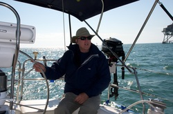
On board were Ken, Danielle and our friend Roger who graciously volunteered to help us with the journey. We headed out of Kemah in to Galveston Bay around 1pm, Saturday, November 17 with the hopes of anchoring near the mouth of the Bay for an early start the next morning. The good weather and light ship traffic changed our minds and we decided to keep going through the night taking two hour shifts. We marveled at the number of lights on the horizon, trying to distinguish between ships and oil platforms.
Over the course of the next three nights and days we made steady and not so steady progress eastward. The nights were cool, downright cold in the wind. A shackle broke one night causing an awful racket as the boom swung free and sail flapped. Ken jerry-rigged a solution out of strapping. Monday night we decided we needed to motor because the winds were out of the east and we just weren't making progress. Tuesday morning we realized the batteries weren't charging and we were starting to lose our electronics. The first hint was the microwave the day before, it wouldn't run more than a couple seconds, but we just thought the microwave was broken. Now we know that was the first sign. With an obviously broken alternator and waning electronics, we made the decision to turn north and head inland rather than try to get east of the Mississippi Delta.
It took all day Tuesday to reach the mouth of the Atchafalaya River, which we did right at dusk. Not wanting to turn the engine off for fear of not getting it started again, we proceeded up the river (20+ miles) in the dark, without a working GPS chart plotter. We encountered our first grounding, very light in soft mud luckily. We were able to flag down some fishermen in a small john-boat who towed us off. The river was well marked, but in the dark it is hard to distinguish where the red and green markers are and which are closer. Thank goodness we loaded the charts on the IPad in a navigation chart app. The IPad has GPS, so between the lit channel markers and the IPad, we slowly made our way up river to Morgan City, arriving around 10 pm at the City Docks. Just before docking we had to cross under our first bridge, a railroad bridge that lifts. The charts said it was 65' when lifted (we are 57'), but let me tell you, it does not look like you will make it as you approach - I think I almost passed out I was so nervous going under. I don't watch anymore when we go under bridges. We were able to hook up to shore power at the dock, have dinner and finally get some uninterrupted sleep.
Wednesday (Nov 21) we set about to get the alternator repaired. The people of Morgan City were wonderful and helped us out at every turn. Roger took a walk around town early and was invited in to a local business for coffee. The shrimper docked behind us answered all our questions and offered us free ice (a luxury on a boat). We called for a cab and took the alternator to a shop about 10 miles away. The owner of the shop drove us back to our boat and delivered the alternator to us later that day. We had high hopes of continuing eastbound on the intracoastal Thursday, but the engine still wasn't quite right after installing the rebuilt alternator. We resigned ourselves to spending Thanksgiving and probably Friday in Morgan City waiting to get the engine repaired. With the afternoon free, I managed to get a nice long (but slow) run in, which was a bonus since I was in the middle of a training schedule for a race in January.
Thanksgiving morning we lucked in to a ride as we started our walk to the Waffle House - everyone was really that nice! At the Waffle House we noticed a truck advertising 'engine repair'. I promptly approached Dominic inside wearing a shirt advertising the same. He offered to come take a look at our engine that afternoon, on Thanksgiving day. On our walk back to the boat we picked up steaks for dinner. Dominic and his 12 year old daughter visited the boat mid-afternoon and he got the engine running in about 5 minutes, yay! Just before dinner we welcomed Ron and Linda, a couple docked next us, on to our boat for drinks and conversation. We were very interested in their experiences traveling the intracoastal, especially through New Orleans and the locks. The rest of the evening we enjoyed our wonderful steaks grilled on the back of the boat and worked out some logistics for Roger's departure the next morning. He decided we could probably manage the next two days on the intracoastal on our own and he could catch the end of the holiday with his family back in Florida.
Friday (Nov 23) morning we waved good-bye to Roger on the dock and started the 40 mile trip down the intracoastal toward Houma, LA, our next planned stop. The scenery went from highly industrial with lots of commercial boat traffic to beautiful wilderness teeming with birds. We docked in Houma where we visited with Ron and Linda again. They would be staying in Houma a few days waiting for some colder weather to pass. We planned to push our way through to New Orleans so we could dock the boat for a month while we returned to work on Monday.
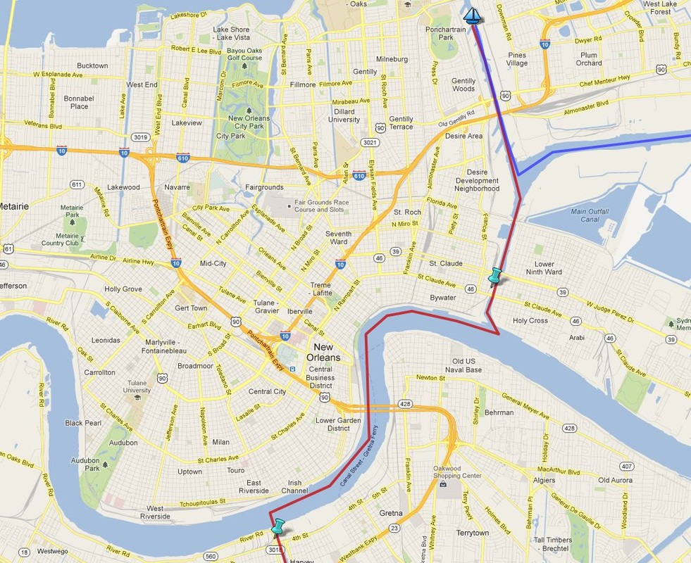
The two push pins are the locks we went through and the boat icon is where we docked the boat for the month of December.
We knew Saturday would be a long day, 60 miles to New Orleans, so we started out at first light. We made great progress all day, called and made plans with a marina off the Industrial Canal (connects the Mississippi River to Lake Pontchartrain) and prepared to go through our first locks. I was nervous about locking, having never done it before, but the Harvey Lock was a breeze. We were the only boat in it and everything went smoothly, other than being told by the lock master we were supposed to wait for the horn to exit the lock after we had already left, oops. Passing through the Harvey Lock put us on the Mississippi River just north (as the river flows, but really southwest) of downtown New Orleans - where the lower blue push pin is on the map here.
Entering the Mississippi River is quite an experience. The first thing you do is call on the radio on Channel 16 to announce your entrance on to the river and your direction (thank you Waterway Guide!). In our case we were 'southbound', but as you can see we were really heading northeast. The directions are crazy and all relative because you are describing your overall direction on the river itself, which is flowing south towards the Gulf. Anyway, we tell the dispatcher we are now on the river and he gives us instructions to change channels to go to 'small craft traffic control'. The new dispatcher instructs us to go to the 'eastbank' (really north) and to return to Channel 16 to monitor commercial traffic. We passed tugs, a fireship, a cruise ship, a paddle boat and many barges. Most were docked, but we just felt so small! Five miles down the river and we were ready to lock off the river and on to the Industrial Canal. We called back to small traffic control and informed them we were leaving the river and to thank them for their help in navigating through New Orleans.
I guess we were spoiled by our experience locking on to the river through the Harvey Lock because this next lock was an escapade! At this point we were only two miles from the marina and still had about 45 minutes of daylight. Home free, right? Nope. First, the lock master asked us to wait for a barge so we could all lock together. There went our daylight. Once the 4-pack barge and tug arrived, we were told to let him enter the lock first and then tie up to the side of the tug. A little nerve-racking, but it went fine. The locking process itself is no big deal. The gates close, the water goes up or down, and the opposite gates open. But, when it was time to leave the lock, the tug captain comes down and yells, "I'm sorry, they never should have put you in here with us, you're screwed (what?!). Just back up as far as you can and I'll go as slow as I can". There wasn't much room left in the lock with the four barges in front of the tug, so there was just a little room behind. The problem was the tug had to really use his thrusters to get the barges moving forward which meant the water behind the tug (where we were) was being pushed all around. Ken did an awesome job going from forward to reverse and back again to keep us from slamming in to the side of the lock, he was so calm, inwardly I was freaking out.
After exiting the lock, there is immediately a bridge. The tug and barges were able to go right ahead being low enough to not need a bridge opening. We were going to have wait for an opening. Between the lock and the marina, there were five bridges, four that we would need to open for us to pass under. We changed from Channel 14 (for locks) to Channel 13 (for bridges) and requested an opening from the Claiborne Bridge. We waited . . . and waited . . . no response. Called again. Nothing. A few more times, still nothing. Were we doing something wrong? Back to Channel 14 to ask the lock master if 13 was the correct channel. Yes. For the next half hour this continued. I think the other bridges who could hear us on the radio were getting tired of us and one offered to try to contact the attendant in the Claiborne Bridge. Finally, a voice comes over the radio profusely apologizing to us and telling us that the prior shift's bridge attendant had turned the radio volume all the way down and he had not heard us. Ok, at least we weren't crazy or doing something wrong. The bridge opens, we pass under, move on to the Florida Avenue bridge. It opens as soon as we radio. Next, the railroad bridge. He also opens within a few minutes of our request. Two bridges to go. The I-10 bridge is plenty high enough, so the Danzinger is the last one we need to open. We approach and radio our mast height and request an opening. The attendant responds that her bridge is only 50 feet. Huh?! I frantically check the Waterway Guide, it is a lift bridge, right? Yes, it is. Ken asks her the same question and she says, yes, she is a lift bridge, but she won't be opening tonight. We are literally one mile from the marina, I could not believe we were going to be stuck here in the middle of the canal for the night. There are curfews on the bridges, but they are associated with rush hour traffic and it is 7:30 pm on a Saturday night, not a stated curfew period. Ken asks her why she isn't opening and she tells us the street lights on the road are out and that she is not comfortable opening with the lights out. Now, she isn't talking about the lights that announce the bridge is going up, those are working fine, she is talking about the regular street lights. After some discussion, she agrees to contact a supervisor. An hour later, the bridge opens!
We motor the final mile and dock at Pontchartrain Landing RV Park and Marina. What a day! This will be the boat's home for the next month. We grabbed dinner at the BBQ place at the park and enjoyed the hot tub. We spent the next day picking up a rental car, cleaning up the boat and packing for the drive home.
We'll be back in December to make the next leg of the trip, hopefully home to Carrabelle.
 Click to go to more photos | 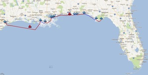 Click map image to go to interactive and annotated map of the trip. |